Sunday, October 3, 2010

Breathtaking Rockies

Disclaimer:
All the humor about wildlife should not be taken literally. We hate disturbing wildlife and hate those doing it.
------------------------------

We were introduced to the mountains at a very young age, thanks to some enthusiastic family members. The fascination continues till date and will hopefully never ever diminish. Therefore, after landing in the States, one of the places on our bucket list was the Rockies. The reason is simple. This encompasses hundreds of 10000 ft mountains including Longs Peak (14255 ft), one of the tallest in mainland US. However, due to some unfavorable situations, it did not materialize initially. Instead, what we got was Smokeys at late fall. Now that’s an altogether different story – subject of a separate blogpost.
Longs Peak
Luck finally favored us at 2010, when we managed back to back trips to the Tetons and the Rockies. Well not exactly the whole Rockies, but Rocky Mountain National Park, which represents the best of the Rockies. The Continental Divide bisects the park into two distinct regions; (i) a heavily glaciated eastern side, and (ii) a heavily forested western side. Both regions boast of outstanding spots for rock climbing, high altitude hiking, and last but not the least, wildlife watching. The time we chose was the beginning of fall, so that we could perceive the region specific fall foliage, much different from what we normally see in New England.
Autumn colors of Rockies

Day 1
The distance from Denver Airport to RMNP is only 80 miles. This is very convenient when compared with the accessibility of other national parks from important airports. The park can be reached either via Boulder or via Longmont. After crossing Lyons, the last 20 miles drive at Hwy 36, accompanied by Little Thompson River, is incredibly scenic.
The heavenly Lake Estes
We usually prefer to camp at the national parks, but this time we made an exception. The picturesque town of Estes Park (elevation 7522 ft above sea level) is strategically placed just outside the eastern entrance of the park. Before entering the town, you will be bewildered by the view of Lake Estes with Prospect Mountain (8900 ft) at the backdrop . Over and above the scenic vistas, the town also provides spontaneous interactions with fearless wildlife, which cares little about the existence of human beings or motor vehicles. Your day could start with greetings from an elk while taking a casual morning walk on the hotel lawns, or end with a deer hitchhiking at the side of the highway. The downtown has plenty of colorful shops for gifts and souvenirs, fine art galleries, historical treasures like the Knoll and Birch Cabin, and a beautiful mountain garden named after Mrs. Walsh, which showcases the local flowers and plants meticulously. Either way, you could spend ample quality time in the town itself, without visiting the park.
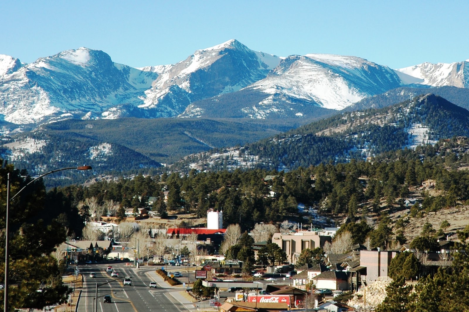
The picturesque town of Estes Park
Nevertheless, the interiors of the park were sending strong electromagnetic waves to our adventurous minds, and we gladly obliged. Needless to say, we were awestruck, not only by the landscape, but also by the changing colors of the season. The added bonus was countless encounters with the abundant wildlife.

The exploration started at Fall River Visitor Center (8240 ft), which serves as the gateway to the Fall River Area. Towards the Endovalley Road, Alluvial Fan (8610 ft) is a unique attraction for people of all ages and should not be missed. The Roaring River passes through a small waterfall and cascading stream down this area. The top of the waterfall is an easy climb and is a great place for shooting (with camera, off course). The small hiking was just a warm up for the upcoming activities.

Old Fall River Road is a 9 mile long one way dirt road which leads to Alpine Visitor Center at Fall River Pass. Major portions of the road are narrow and interposed with tight switchbacks. It is a challenge for all motorists to go uphill on that super-winding road and enjoy the view at the same time. Just 2 miles up the road, we were blessed by the Chasm Falls, which is one of the many natural wonders inside the park. In one of the switchbacks, I was so mesmerized by the view of Mount Chapin (12454 ft) that I had almost managed to get the car into the Chapin Creek. Thanks to our reflexes for noticing that at the last moment. Near the end of this road, it traverses the headwall of Fall River Cirque before joining Trail Ridge Road next to Alpine Visitor Center (11796 ft).
Chasm Falls at Old Fall River Road
From Alpine Visitor Center one can experience sweeping views of the mountain range, combined with diverse wildlife grazing peacefully on the meadows. The visitor center is located amidst Trail Ridge Road, which is probably the highest continuous paved highway of the nation. Spanning 50 miles between Estes Park on the east and Grand Lake on the southwest, 11 miles of this highway travels above treeline (>11000 ft). Unfortunately, the southwest-bound route was closed due to construction work. That deprived us the visit to Grand Lake and the whole southwestern part of the park, which we regret till date.
Trail Ridge Road from its highest point
Anyway, we had no choice but to detour through the eastbound route. From Fall River Pass to Deer Ridge Junction (8930 ft), this 19 mile stretch winds viciously across the alpine tundra and offers stunning landscapes and magnificent wildflower displays. The highest point of this motorable road (12183 ft) is a couple of miles away from Fall River Pass. The other important pullouts include Gore Range Overlook (12010 ft), Lava Cliffs (12000 ft), Rock Cut (12050 ft) and Forest Canyon Overlook (11716 ft). Near the latter one, we could capture the romantic moods of a number of mule deers, with Sundance Mountain (12466 ft) at the background. Some of them came pretty close to the road and were observing the visitors innocently. In accordance with our previous experience at Yellowstone, those happy-go-lucky guys are more camera-friendly than ever.
An Odocoileus hemionus couple at Forest Canyon
The day ended on a high note with group wildlife watching at multiple sections of West Horseshoe Park and Sheep Lakes (8520 ft).

Day 2
We planned to spend the next day on the southeastern region of the park. So we started from Beaver Meadows Visitor Center (7840 ft) and traveled through Bear Lake Road, which exhibits great scenery throughout its 9 mile length.
Big Thompson River meandering through Moraine Park
On the previous day, we had a glimpse of the wildlife at Moraine Park. This morning that expansive valley was infested with large number of bull elks bugling along with their herd. Oblivious of the human intruders, they seem to enjoy their polygamous lifestyle to the fullest extent. The Moraine Park Visitor Center (8140 ft) houses an excellent museum. The wildlife exhibits and interactive geological displays are quite informative.
A herd of Cervus canadensis at Moraine Park
Around 6 miles on the Bear Lake Road, the tranquil Sprague Lake (8690 ft) emerges out from nowhere. The wheelchair accessible 0.5 mile roundtrip trail adjoining the lake is an easy stroll for all ages. This place is ideal for picnicking, bird watching, fishing, or just relaxing. With a little luck, one can also be able to see elks nearby.

The last portion of Bear Lake Road dramatically winds through striking golden colors of the Aspen leaves, signifying better times ahead. The Bear Lake Perimeter Trail (9475 ft), as the name suggests, spans 0.5 mile surrounding the Bear Lake. True to our expectations, brilliant colors of fall foliage were portrayed on the edge of the lake. We were surprised to find some enthusiastic smaller mammals and birds, who spontaneously posed with us for snaps.
Representative Autumn colors at Bear Lake
After walking around this easy trail, we went up further to explore the series of immaculate lakes. The Emerald Lake Trail starts with Nymph Lake (0.5 mile from trailhead), passes through Dream Lake (1.1 miles) and ends at Emerald Lake (1.8 miles). The trail was fairly steep and gains 605 ft at Emerald Lake from the trailhead. Due to time constraints, we resisted the temptation to hike the Flattop Mountain Trail (9 miles roundtrip), which leads to Flattop Mountain (12324 ft) and Hallett Peak (12713 ft).
The serene Nymph Lake
The next destination was Alberta Falls, a gorgeous waterfall towards Glacier Gorge. This 1.6 miles roundtrip trail starts at Glacier Gorge Trailhead (9240 ft), and it starts out smoothly. After a short time, it gets much steeper and we found ourselves in an open area with panoramic views of the surrounding mountains. This being the final hours of daytime, our energy level had dropped exponentially. Still we managed to complete the trail; our impending Grand Canyon trip served as the inspiration. The Glacier Creek guided us through the rest of trail until the sudden appearance of Alberta Falls upfront. Though the downhill return was relatively easy, our aging knees and hurting feet started to revolt.
Alberta Falls, ornamented by Fall Foliage
The return drive to Estes Park was pretty lively. An elk couple blocked both ways of the road, probably didn’t want us to leave to park. It’s always difficult to say goodbye to them. Convincing them about our future return was also a tough job. After we managed to arrive at Estes Park, we went on to explore the downtown on foot. With the Fall River at its side, the mile-long Riverwalk is a peaceful pathway for pedestrians. As I had said earlier, the town is endowed with a plethora of activities, which did not cease to surprise us.

Day 3
To optimally utilize the residual half day before our return flight, we started early in the morning roaming around Lake Estes. The 3.8 mile trail around the lake was impossible to cover completely in this short time, so we had to be content with half a mile or so. Similar thing happened with the two trails on Peak-to-Peak Scenic Byway, namely the Lily Mountain Trail and the Twin Sisters Trail. These trails lead to, as the names suggest, Lily Mountain (9786 ft) and Twin Sisters Peaks (11428 ft), respectively. Finally, we had to bid adieu to the mountains from the Longs Peak Trailhead, and continued our journey through the same scenic highway.
The tranquil Lily Lake
After exploring most of the accessible areas of the park, we realized that there are still so many things left out. A scenic drive in car with no hiking takes you from sprawling meadows to pristine lakes, from vibrant wildflowers to thick snow above treeline, not to mention the juxtaposed wildlife. But to really identify the hidden treasures of the Rockies, one should heartily spend substantial time and energy on the trails.
Bursting fall colors at "Peak to Peak Scenic Byway"

Sunday, September 5, 2010

Gateway to Tetons

Disclaimer:
All the humor about wildlife should not be taken literally. We hate disturbing wildlife and hate those doing it.
----------
…..Contd from previous post…..

With heavy heart and contented mind, we continued our exploration through John D Rockefeller Memorial Pkwy towards Grand Teton National Park. At a particular point on the road, the snowy, toothy Teton Range exploded into view, and our fingers started itching for the shutter (of camera, off course).

The park is named after Grand Teton, the tallest mountain in the Teton Range located at the northeastern edge of the Rockies. The jagged snow-capped peaks and their reflections on pristine alpine lakes are the principal features of the park. Add to that vast wilderness and abundant wildlife; you get a heavenly feeling all through your stay.

Heaven on Earth

Just outside the park boundaries we received a warm welcome from a black bear, indicative of better times inside. True to our expectations, we were blessed by countless interactions with permanent residents of the park, namely bears, elks, bisons, mooses, deers and antelopes. 

The gatekeeper of park boundaries: Ursus americanus

The mesmerizing beauty of the shimmering waters of Jackson Lake was enhanced by its awesome backdrop, a cutout of a portion of the Teton Range. After drenching ourselves in the bedazzling beauty of the landscape, we went on to explore the Snake River along the scenic Grassy Lake Road. Being a dirt road, this is not so popular among tourists, but offers serene sunset view along the Glade Creek. 

Sunset along Snake River

Day 6
Next morning, the other popular scenic drive around the south of Jackson Lake led us to the top of Signal Mountain, which tenders 360° panoramic views of the four mountain ranges: the Tetons, Gros Ventres, Wind Rivers, and Absarokas. The vast green stretched for miles below was a variation from our everyday views, something that makes a permanent mark in our minds.

The best place to watch wildlife in the morning is Oxbow Bend. The river otters, bald eagles and American white pelicans hunt for fish at the slow-moving waters of Snake River around this area. A herd of elks can be seen quite often grazing in the open aspen groves. In the afternoon, Blacktail Ponds Overlook is the best bet to watch a number of mooses and bisons. We also observed a grizzly far away walking in the shallow waters of Snake River. Pronghorn antelopes were abundant in the nearby Antelope Flats Road and the Mormon Row dirt road, oblivious of the gawking human beings.

The curious Antilocapra americana
A family of Bison bison

After we have covered almost everything in the park, we drove along the Moose-Wilson Road towards Teton Village. The village is just outside the park boundaries and offers a spectacular ride on an aerial tramway, which took us to the summit of Rendezvous Peak. The ride to the top also offered us a glimpse of a moose wandering on the slopes of the mountain. The view from the top, to say it mildly, was captivating.

Female Alces alces near Moose-Wilson Road

From the summit of Rendezvous Peak (10927 ft)

We had planned to stay the night at the Climber’s Ranch maintained by American Alpine Club. At the entrance of the ranch, we were overwhelmed by the guard of honor given to us by a group of pronghorns and white-tailed deers. The entry to log cabins from the gate of the ranch was a feast for the eyes with the Teton Range on one side and a small stream of water flowing by. The perfect calmness and tranquility of the atmosphere enhanced nature’s glory even more. As darkness seeped into foothills of the mountains, we were awestruck by the act that was exposed in front of our eyes. It seemed as if a curtain was raised and new act was beginning to play. With absolute pitch darkness everywhere, the only thing you can do is sit on the porch and look up. The sky above was decked in its own way and the infinite number of glittering stars of various sizes studded on it just gave a new dimension to the whole view. The soft sound of the faint breeze that rustled the leaves was the only sound that could be heard. Our fellow campers had arranged for a camp fire. Fighting the immense attraction to spend some more time outside, we decided to call it a day as we had a long day ahead the next day.

Guard of Honor from Odocoileus hemionus

Day 7
Next morning, we started our long drive towards Salt Lake City via the picturesque town of Jackson Hole. A short detour to Fossil Butte National Monument added a quiet but fascinating layer to the day. The landscape may seem unassuming at first, but it holds remnants of an ancient lake, preserving delicate fossils from millions of years ago. The museum exhibits brought this ancient world to life, and we even picked up a small memento, an actual fossil, as a tangible reminder of that period. Further along, the drive toward Rubey Point turned out to be unexpectedly rewarding. The road was calm and largely empty, with expansive views unfolding gradually as we climbed. From there, the long drive to SLC Airport marked the conclusion of our travelling spree.

Sunday, August 1, 2010

The First National Park

Disclaimer:
All the humor about wildlife should not be taken literally. We hate disturbing wildlife and hate those doing it.
------------------------------------------------------------

The explorers of this universe can be categorized into two types: those who have already visited Yellowstone, and those who WILL visit there.
If you live in the States and have the option of making one last trip in the rest of your life, what would be your choice? The only place that should come up in your mind is Yellowstone National Park. Not Grand Canyon, not Niagara Falls, not Rockies, only Yellowstone. The “first national park” in the world is truly an incredible place to perceive and should be in everyone’s bucket list.
Approximately 96% of the park area is located in the state of Wyoming; the remaining 4% lies in Montana and Idaho. The Continental Divide of North America runs diagonally through the southwestern part of the park. The park sits on the Yellowstone Plateau, surrounded by mountain ranges of the Middle Rocky Mountains, at an average elevation of 8000 ft above sea level. The Yellowstone Caldera is the largest volcanic system in North America. Its formation was brought about by extremely large eruptions, the last of which occurred six hundred thousand years ago. The park was named after one of its major attractions, the Yellowstone River. The “Yellowstone” term was coined from the local Minnetaree language meaning “Rock Yellow River”. The source of the Native American name is not clear.
The greater Yellowstone ecosystem supports a wide variety of wildlife, such as grizzly bear, American black bear, bison, wolf, mountain lion, elk, mule deer, moose, bighorn sheep, whitetail deer, mountain goat and pronghorn antelope. They are so abundant in number that you need not go looking for them. They will find you and show tremendous enthusiasm for photo sessions. Their attitude towards human beings ranges from very friendly to very egotistic. This rich combination of geological features, quaint landscape and profuse wildlife is what makes Yellowstone a unique destination for people of all ages.
Since Grand Teton National Park is only 8 miles south of Yellowstone, a wise decision is to encompass both the parks in a single trip. Jackson Hole is the nearest airport to GTNP, but it’s difficult to find cheap flight deals to there. The most optimum way to reach Yellowstone is to drive 250 miles from Salt Lake City international airport. We saw ample flight deals to SLC when we lived in a small college town in Texas. But our dear bosses were so concerned about our careers that, not only they engaged us in a busy research schedule, but also did not grant few days leave. Tired with the bosses and frustrated of the Texas heat, we moved to the northeast for better career and climate. Then we realized how difficult it was to find cheap flight deals from Boston to SLC. So the idea gradually drifted to the backseat.
While the return to Swades was looming over the horizon, we made a desperate attempt to visit Yellowstone in the summer of 2010. Managing a week’s holiday around the 4th of July weekend was not that difficult, thanks to our new advisors. This particular time we didn’t care about flight expenses.

Day 1
Though the flight ticket was not that cheap, still we had to fly from Providence, which is about 70 miles south of Boston. All the northeast airports have unreasonably high parking fees; so we had to opt for public transport to reach PVD. The flight to SLC via Chicago was long and boring, and arrived pretty late in the night. A good old friend generously offered to accommodate us for the night along with refreshments, so that we could get a shut eye.

Day 2
Next morning, the drive to Yellowstone was eventful. It was pretty smooth until Pocatello through I-15. The real pain started after switching to SH-20 at Idaho Falls. Due to “n” number of roadwork around the Targhee National Forest and inside the park boundaries, the total travel to Canyon Village took 8 hours instead of 5. Some of the roadblocks near Madison Junction were unexpectedly made by the grazing bisons, oblivious about the suffering of their fellow mammalian species, namely the Homo sapiens. One of them, in his natural course, almost hit our rental car but missed by a whisker. We vented our anger on the stubborn guy by not taking his photo, which we started regretting moments after we left the spot. However, this did not last very long.
Bison bison - The self proclaimed traffic police of Yellowstone

We have tried out camping in all the national parks in the States, and this was no exception. Fortunately we could reserve a campsite in Canyon Village just one month before our trip. Those who have visited Yellowstone in summer would know how difficult it is to find an accommodation inside the park. Though the town of West Yellowstone offers some reasonable roofs over your head, staying inside the park was our first priority. Our expectation was to meet a grizzly bear or two near the campsite, but luck is not what we had. Our fellow travelers were smart enough to use closed containers to lock their food, the smell of which attracts the Ursus species.
After checking in at the campground, we went to explore the surrounding Grand Canyon of Yellowstone. We bumped into a couple of bisons just outside the Canyon Village, who were taking afternoon nap in a royal fashion. By this time we got so frustrated by their gigantic egos that we stopped requesting them for shooting (with camera, off course).
The Inspiration Point is located at the far end of the road where the canyon wall juts out into the canyon allowing spectacular views of Yellowstone River both upstream and down. Along the road, the Lookout Point and Grandview Point are two other popular vista points which offer further breathtaking views of the river. The Red Rock Point is near a tall reddish pinnacle of rock below the Lower Falls, which got its red pigmentation from iron oxide.
Grand Canyon of Yellowstone

Among the two famous waterfalls on the Yellowstone River, the Upper Falls stands at a higher elevation, but is significantly shorter (109 ft) than its downstream neighbor. The Lower Falls is the tallest waterfall in the park at 308 ft. Though there are designated vista points for both the falls, Uncle Tom’s Trail offers an up close and personal interaction with the Lower Falls. Since this trail is very strenuous and it was almost getting dark, we postponed our plans for hiking and continued driving towards the Artist Point. The most picturesque views of the canyon can be best witnessed from this point. On the way we met a smart and friendly elk, who happily agreed to pose with us for a snap. We really liked the chap’s sportsman spirit, and encourage everyone to be like him. Because of him, the day ended on a very high note.
Our ever-smiling friend Cervus canadensis

Day 3
The next day started with driving along the Dunraven Pass. Bear sightings are very common in this area, and our Ursus friends were benevolent enough to ensure that we were not disheartened. The first one was a grizzly wandering with her two cubs far along the slopes of Mount Washburn. We had to use a 70–300 mm zoom lens to watch them, but the photos were still unclear. The second one was a black bear roaming pretty close to the road, but the jamboree of too many curious human beings trying to close in pushed our beloved friend further into the woods. Frustrated with the insensible tourists, we continued driving through the Tower-Roosevelt junction.

The rapids of Yellowstone River near Tower-Roosevelt Junction

Tower Falls, created by 132 ft drop of the Tower Creek, is the most discernable natural feature in this district. Ignoring the protests of our aging bones, we walked down the trail to the bed of Yellowstone River. Along this region of the river, a group of thermal springs signals the downstream end of the Grand Canyon of Yellowstone. The steep, columnar basalt cliffs on the opposite side of the river are remnants of an ancient lava flow, opening a window into the past volcanic forces that shaped much of the Yellowstone landscape.
Yellowstone being a massive caldera of a volcano, has one of the world's largest petrified forests, trees which were buried by ash and soil and transformed from wood to minerals. The Petrified Tree, located near the Lost Lake trailhead, is an excellent example of an ancient redwood, similar to the many found on Specimen Ridge. Except for some isolated sightings of quite a few bison families at Blacktail Deer Plateau, our drive towards Mammoth Hot Springs was uneventful.

Petrified Tree

The key ingredients essential for the formation of the terraces of Mammoth Hot Springs are heat, water, limestone, and a rock fracture system through which hot water can percolate to the earth's surface. Throughout the year, the terrace features change rapidly in appearance. The important springs at the Lower Terraces include Opal Spring, Palette Spring, Minerva Spring, Cleopatra Spring, Canary Spring, to name a few. The springs are famous not only for a wide range of dazzling colors but also for ornate travertine formations. The Canary Spring, highly recommended by my friend at SLC, is famous for its brilliant orange yellow color due to sulfur dependent filamentous bacteria. A 37 ft hot spring cone known as the Liberty Cap marks the northern portion of the Mammoth Hot Springs. From the Overlook, one can have a great view of the Main Terrace and the surrounding mountains.

Canary Spring at Mammoth Hot Springs 
The Upper Terraces can be portrayed by Prospect Terrace, New Highland Terrace, Orange Spring Mound, Bath Lake, White Elephant Back Terrace and Angel Terrace. The Orange Spring Mound is distinctly different from the nearby terrace formations in terms of the bright orange streaks of color contrived by bacteria and algae. Whilst roaming around the Upper Terraces, we caught glimpses of a bunny and as well as a mountain snake, who despite being venomous, concealed him/herself hurriedly from the human eyes. Dejected by his/her unfriendly behavior we quietly had our lunch along with an elk family near Fort Yellowstone. So different were our food habits that we could not share anything with them.

During the drive towards Norris Geyser Basin, we had reasons to cheer up again. A couple of grizzlies were basking in the afternoon sun exceptionally close to the road. Known amongst friends to be shutterbugs, we could not help but capture these intimate moments. Since we did not wish to perturb their romantic mood, we silently left them alone. Unbelievable but it was third bear sighting of the day, and not the last.

Our beloved friend Ursus arctos

Norris Geyser Basin is not only the hottest but also an everchanging thermal area in Yellowstone. This is the location of the tallest active geyser, colorful hot springs, fumaroles and microscopic life in one of the most extreme environments on earth. Two loop trails, which begin from the Norris Museum, provide a safe route to wander around the area. Porcelain Basin has an open terrain with hundreds of densely packed geothermal features, namely Black Growler Steam Vent, Ledge Geyser (2nd  largest geyser in Norris), Congress Pool, Blue Geyser, Whirligig Geyser, Whale's Mouth, Crackling Lake, to mention just a few. Although most of these thermal features contain highly acidic water, several living organisms like lime-green Cyanidium thrive even in these extreme environments. From a distance these bacteria look like rusty, iron-rich mineral deposits. These and other microscopic life forms are direct links to the emergence of life on earth billions of years ago.
Porcelain Basin at Norris Geyser Basin

In contrast to Porcelain Basin, the Back Basin is forested and its features are more scattered and isolated. It is famous for the world's tallest active geyser, the Steamboat Geyser. At its best, Steamboat can erupt to a whopping 300 ft, showering viewers with its mineral-rich waters. Being unlucky as usual we had to be content with a less than 50 ft show. Other crucial features in the vicinity include Emerald Spring, Cistern Spring, Echinus Geyser, Green Dragon Spring, Porkchop Geyser and Minute Geyser.
The great diversity of thermal features at Norris Geyser Basin is fundamentally due to its location at the intersection of several commotions in the earth's crust. A major rock fracture runs south from the Mammoth Hot Springs area toward Norris, which crosses another eastbound fault from Hebgen Lake to Norris. Both of these cracks in the earth's surface intersect with fractures radiating from the central Yellowstone caldera, which creates a unique landscape on this continent.
The whole experience at Norris left us exhausted. The attraction of Hayden Valley was pricking us from inside, so we spent little time at Mud Volcano and Sulphur Cauldron areas. Hayden Valley is probably the best place in the park to view diverse wildlife. When we parked our car on the roadside amidst a huge number of tourists, a live drama between a mighty grizzly, her two cubs, a lone wolf and two opportunist coyotes was already going on. Apparently the lone wolf hunted down a poor elk the day before injuring himself in the process, and the mighty grizzly had managed to overpower him to take possession of the carcass. When the wolf rightfully wanted to retrieve his prey, he was badly slapped by the mother bear who was already feeding her two cubs. Hurt both mentally and physically, the lone wolf limped towards the bank of the creek, where the two opportunist coyotes were patiently waiting for the mother bear to leave the place. Just a few yards away, some bisons with majestic personality were leisurely enjoying the last rays of day’s sunlight; little did they care about the excitement going on beside them. The unfolding of this drama left us so spellbound that we were looking for analogies to the great Indian politics. Though we felt sorry for the lone wolf and the dead elk, we did not forget to record the whole act, hoping to enlighten my politically aware friends. As dusk was setting in, the wise guys of the park advised us to return to our respective shelters.
Old jungle proverb, "Don't mess with the Grizzly"

Day 4
We intended to start our day at the Upper Geyser Basin, which has the largest concentration of geysers in this part of the world. The visitor center made a comprehensive list of the prominent geysers with their eruption timings, which facilitate visitors to plan accordingly. At the south section, Old Faithful Geyser is the most popular one due to its consistency of eruption at regular intervals. The average interval between two eruptions is about 90 minutes; a single eruption lasts between 2 and 5 minutes, and reaches a height of more than 100 ft. We reached there just in time to grab a convenient seat at the observation deck.
The grand show of Old Faithful Geyser

After the grand show of Old Faithful was over, a short climb to the Observation Point allowed us to experience spectacular views of the Upper Geyser Basin. The other geysers in this area known for violent and tall eruptions include Giantess Geyser, Plume Geyser, Beehive Geyser, Grand Geyser, and Castle Geyser at the south section; and Giant Geyser, Splendid Geyser, Daisy Geyser, and Riverside Geyser at the north section. The timing of Daisy Geyser was comfortable for us, so we could manage to watch its eruption to a height of about 70 ft. The one geyser which surprised us most is Beehive. Its untimely eruption of about 130 ft height was a viewer’s delight. Situated on the bank of the Firehole River, Riverside Geyser is probably the most picturesque geyser in the park.
Desert flower at Upper Geyser Basin

There are a number of geysers whose eruptions are short in height, but are more frequent and equally magnificent like their taller siblings. These comprise of Solitary Geyser, Lion Group of Geysers (connected underground), Sawmill Geyser, Comet Geyser, Grotto Geyser, and the twin Fan & Mortar Geysers. Along with the geysers, the region is complemented with numerous pools and hot springs having remarkably beautiful colors. The most prominent of these are Doublet Pool, Heart Spring, Crested Pool, Beauty Pool, Chromatic Spring and Punch Bowl Spring. The names are self-explanatory, so we would not waste time describing them. The Morning Glory Pool at the extreme end of the north section is a favorite destination for the park visitors owing to striking resemblance with its namesake flower. All the pools and springs are characterized by orange and yellow bacteria at the periphery and crystal blue water at the center.
Morning Glory Pool

Three miles north of Old Faithful lays the Biscuit Basin, named so for unusual biscuit-like deposits surrounding the Sapphire Pool. Other notable colorful features in this basin are Jewel Geyser, Shell Geyser, Avoca Spring and Mustard Spring. The Firehole River running through the Upper, Midway and Lower Geyser Basins derived its name from the steam witnessed by early explorers in this region.
Firehole River near Black Sand Basin

The hydrothermal activity at the Lower Geyser Basin can be viewed along the boardwalk trail at Fountain Paint Pots and along the three mile scenic Firehole Lake Drive. At the middle of this one-way drive we were fortunate enough to witness the rare eruption of Great Fountain Geyser to about 100 ft height. The Firehole Canyon Drive is another one-way scenic drive following the Firehole River upstream from Madison Junction to Firehole Falls, which stands at around 40 ft.
The Midway Geyser Basin is relatively small compared to its Upper counterpart, but holds enormous wonders for the guests. The Excelsior Geyser has a gaping crater of dimensions 200 ft x 300 ft with a steady release of water into the Firehole River. The Grand Prismatic Spring is the largest hot spring in the park, with a diameter of 370 ft and depth of 121 ft. Both the features should be viewed from the sky - which is next to impossible - to enjoy their bursting beauty. The Grand Prismatic Spring deserves a dedicated travel review, and we would not dare to describe its beauty here in few words.
Grand Prismatic Spring

By this time, the temperature, humidity and interaction with the innumerable geysers and hot springs drained us out. We gathered the last bit of our strength to explore the area surrounding Yellowstone Lake. At an elevation of about 7700 ft, it is the largest high altitude lake in the continent. The Fishing Bridge at the Lake Village is a historically popular place to observe fish, but has been closed for fishing since 1973. From the Lake Village, a 9 mile drive towards the East Entrance took us to Lake Butte. Standing at about 8300 ft above the sea level, this vista point offers stunning panoramic views of the lake with Teton Range at the backdrop. During the return to Canyon Campground via Hayden Valley we had expected some more live drama, but destiny had written something else. The remains of the poor elk had vanished, and gone with it were the predators. Except for a few herbivorous bisons and a large number of omnivorous human beings, there was nothing interesting to watch in this area.
Yellowstone Lake from Lake Butte

Day 5
This was supposed to be our last day at Yellowstone. So the plan was to cover the few remaining areas starting with Lower Falls of the Yellowstone River. As mentioned before, Uncle Tom’s Trail presents an intimate interactive session with the falls. The trail is very strenuous and drops 500 ft in a series of more than 300 stairs and paved inclines inside the canyon. Our timing to reach the bottom of the trail was so designed that the rainbow created by dispersion of sunlight through the water droplets could be envisaged. Climbing up the trail was backbreaking, but we considered that as a preparation for the upcoming Grand Canyon experience.
The rainbow at the bottom of Uncle Tom's Trail

The next destination was the West Thumb of Yellowstone Lake, which contains the West Thumb Geyser Basin. The basin has several hot springs and pools; the famous amongst them are Abyss Pool, Black Pool, Thumb Paintpots, Lakeside Spring, Big Cone and Fishing Cone. Fishing Cone is a hot spring located inside the waters of the lake, and erupts frequently to a height of 10 ft. Without this experience, the visit to Yellowstone would be incomplete.
A friendly encounter with an elk family at the entrance of West Thumb concluded our stay at Yellowstone National Park. Being exceedingly cordial they were unwilling to leave us, but finally bid us farewell with moist eyes. With heavy heart and contented mind, we continued our exploration through John D Rockefeller Memorial Pkwy towards Grand Teton National Park.
…..to be contd…..